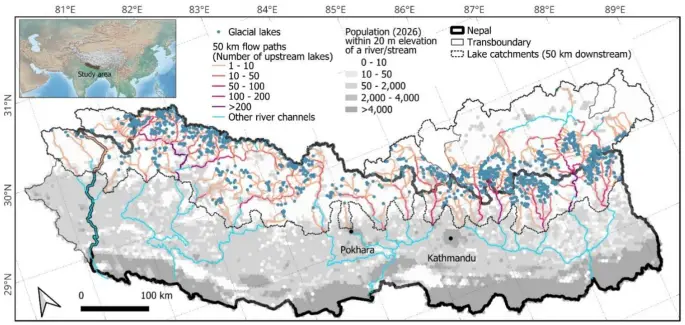
Construction in areas potentially exposed to flooding has increased significantly in mountain catchments in the Himalayas, according to a study. In Nepal and cross-border areas of India and China, the total area covered by buildings at elevations up to 50 metres above nearby riverbeds increased by 46% between 2016 and 2023. In zones covered by modelled scenarios of flooding from glacial lakes, the increase was around 77%. The percentages refer to building area and potential exposure, not recorded floods or damage.
These mountain regions are affected by summer monsoons, extreme rainfall and water flows carrying large amounts of sediment and debris. An additional source of flooding is the sudden drainage of glacial lakes, a phenomenon known as a GLOF. The researchers explain that retreating glaciers create more lakes, while warming, permafrost degradation and slope instability create conditions that favour flood events. Meanwhile, settlements, tourist facilities and infrastructure are expanding within the valleys.
To examine this change, the researchers studied catchments with glacial lakes and drainage routes extending up to 50 kilometres downstream. They used the HAND index, which records a location's height above the nearby drainage channel. In steep valleys, this approach gives a different picture from using a fixed horizontal distance from the river, because the ground can rise rapidly. They also combined building maps with published flood scenarios for glacial lakes with a high outburst potential.
The maps' reliability was examined separately, as five open datasets showed large discrepancies in the number and area of buildings. They were compared against 5,994 buildings mapped manually at 13 sites. Google Open Buildings Temporal 2.5D had the highest median F1 score, at 0.68, compared with 0.62 for Google Open Buildings V3, and was the only dataset that allowed comparisons between different years. Even this dataset, however, contained omissions and misidentifications, while differences in image dates limited comparability. The authors preferred area to building counts because automated methods can merge neighbouring structures into a single outline.
The area covered by buildings in the 0–50-metre elevation band increased from 12.38 to 18.04 square kilometres. The upward trend was evident in the parts of Nepal and China examined, while no clear change emerged in the smaller Indian section. In Nepal, exposure was concentrated mainly in the lower parts of the catchments. On the Tibetan Plateau, broader and flatter landscapes allowed construction at elevations closer to riverbeds, unlike the narrow, steep valleys of Nepal and India.
Population estimates based on WorldPop data indicate that in 2026 around 293,800 people, or 18% of the population of the catchments examined, are in the zone 0–50 metres above watercourses. If only the drainage routes of glacial lakes are considered, the estimate falls to 144,400 people, around 9% of the total population. Of these, about 108,500 are in Nepal. Across all watercourses, projections indicate a population increase in the same elevation band of 17,900 people, or 6%, between 2015 and 2030.
These figures come with considerable uncertainty: validation of WorldPop was limited to 2021 census data from 140 administrative units in Nepal. Comparable verification was not possible for different years or for the entire study area. In addition, such population models may underestimate scattered rural populations, while the census also records population declines in some mountain areas due to migration. Annual maps also do not capture daily movements or whether a building is occupied at the time of a flood.
The authors link the expansion of construction to tourism, hydropower facilities and other infrastructure, alongside the limited implementation of land-use plans. For Nepal, they note that planning policy takes natural hazards into account, but lacks corresponding regulatory implementation. Development within river corridors and low-lying floodplains can restrict natural flow paths and the space available to temporarily store water. As a specific example, they cite the destruction of the Timure dry port in Nepal, which had been built beside the river, by a cross-border glacial lake outburst flood in 2025.
Greater exposure alone is not enough to calculate potential human or economic losses. HAND is an indicator of relative topographic exposure and does not describe a flood's depth, speed or frequency, or temporary dams and other dynamic processes. The researchers recommend better data validation, more detailed topographic mapping and combining these with flood models and social vulnerability indicators. Updated maps could then support spatial planning, adaptation investments and early warning systems, both nationally and in catchments that cross borders.

Comments